Although the tropical wave that formed last week is not expected to strengthen, another tropical wave has popped up as a potentially bigger threat to begin August.
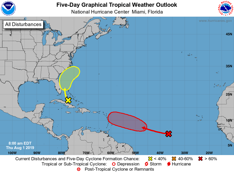
According to the National Hurricane Center in Miami, Fla., a broad low pressure system located about 1000 miles west-southwest of the Cabo Verde Islands continues to produce a large area of
disorganized showers and thunderstorms. The weather system is moving west-northwest at 10 to 15 miles per hour, but conditions are favorable for it to strengthen into a tropical depression over the weekend.
The first tropical wave, which has only a 10 percent chance of forming into a tropical cyclone, is currently located north of Cuba and is expected to head north-northeast up the mid-Atlantic coast.
The second tropical wave, which has a 70 percent chance of forming into a tropical cyclone over the next five days, is currently several hundred miles east of the Lesser Antilles.
The next named tropical storm would be Chantal, according to the National Hurricane Center’s list of 2019 Atlantic storm names.

2019 Atlantic Tropical Storm / Hurricane Names:
AndreaBarry- Chantal
- Dorian
- Erin
- Fernand
- Gabrielle
- Humberto
- Imelda
- Jerry
- Karen
- Lorenzo
- Melissa
- Nestor
- Olga
- Pablo
- Rebekah
- Sebastien
- Tanya
- Van
- Wendy


Be the first to comment