
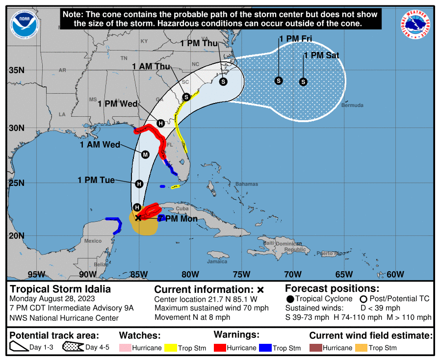
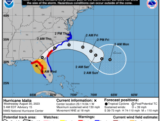
As of 5 PM EDT on Monday, Tropical Storm Idalia has begun moving northward at 8 MPH and Maximum sustained winds have increased to 70 mph, just below hurricane
strength. Idalia is expected to strengthen and is expected to become a Major Hurricane on Tuesday over the eastern Gulf of Mexico. Idalia is forecast to make landfall early Wednesday along Florida’s Nature Coast as a Major Hurricane.
Tropical Storm Idalia Local Statement Advisory Number 9
National Weather Service Tallahassee FL AL102023
537 PM EDT Mon Aug 28 2023 /437 PM CDT Mon Aug 28 2023/
This product covers eastern Florida panhandle, Florida Big Bend,
southeastern Alabama and southwestern Georgia
…LIFE-THREATENING STORM SURGE AND DANGEROUS WINDS BECOMING
INCREASINGLY LIKELY FOR PORTIONS OF FLORIDA…
NEW INFORMATION
—————
* CHANGES TO WATCHES AND WARNINGS:
– The Tropical Storm Warning and Hurricane Watch have been
upgraded to a Hurricane Warning and the Storm Surge Watch has
been upgraded to a Storm Surge Warning for Coastal Franklin
– The Tropical Storm Warning has been upgraded to a Hurricane
Warning for Inland Jefferson
– The Hurricane Watch has been upgraded to a Hurricane Warning
for Lanier and Lowndes
– The Tropical Storm Watch has been upgraded to a Hurricane
Warning for Brooks
– The Tropical Storm Watch has been upgraded to a Tropical Storm
Warning for Thomas
– A Tropical Storm Warning has been issued for Coastal Gulf,
Gadsden, Grady, and Inland Gulf
– A Hurricane Watch has been issued for Inland Wakulla and Leon
– A Tropical Storm Watch has been issued for Berrien, Colquitt,
and Cook
* CURRENT WATCHES AND WARNINGS:
– A Storm Surge Warning and Hurricane Warning are in effect for
Coastal Dixie, Coastal Franklin, Coastal Jefferson, Coastal
Taylor, and Coastal Wakulla
– A Tropical Storm Warning and Hurricane Watch are in effect for
Inland Wakulla and Leon
– A Hurricane Warning is in effect for Brooks, Inland Dixie,
Inland Jefferson, Inland Taylor, Lafayette, Lanier, Lowndes,
and Madison
– A Tropical Storm Warning is in effect for Coastal Gulf,
Gadsden, Grady, Inland Franklin, Inland Gulf, Liberty, and
Thomas
– A Tropical Storm Watch is in effect for Berrien, Colquitt, and
Cook
* STORM INFORMATION:
– About 580 miles south of Steinhatchee River
– 21.4N 85.1W
– Storm Intensity 70 mph
– Movement North or 360 degrees at 8 mph
SITUATION OVERVIEW
——————
As of 5 PM EDT, Idalia has begun moving northward at 8 MPH and
Maximum sustained winds have increased to 70 mph, just below hurricane
strength. Idalia is expected to strengthen and is expected to become a
Major Hurricane on Tuesday over the eastern Gulf of Mexico. Idalia is
forecast to make landfall early Wednesday along the Nature Coast as a
Major Hurricane.
The potential for life-threatening storm surge around the shores of
Apalachee Bay continues to increase. Storm surge will be highly
dependent on the storm track, with the highest surge values along and
to the right of the center. Storm surge could start to build as soon
as Tuesday afternoon, with peak surge values coming on Tuesday night
and Wednesday.
A Storm Surge Warning is now in effect from Indian Pass to the Suwanee
River for the danger of life threatening inundation from rising water
moving inland. Storm surge inundation above normally dry ground could
reach the following heights, if the peak surge occurs with high tide:
1 to 3 feet from Mexico Beach to Indian Pass, 3 to 5 feet from Indian
Pass to the Ochlockonee River, 5 to 8 feet from the Ochlockonee River
to the Aucilla River, and 8 to 12 feet from the Aucilla River to the
Suwannee River. The deepest water will occur along the immediate
coast, where the surge will be accompanied by large and dangerous
waves.
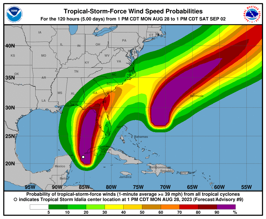
In addition, the odds of hurricane force winds are increasing over the
southeast Big Bend Region into the lower I-75 corridor of Southwest
Georgia, and the forecast hurricane intensity at landfall remains
nearly steady since the last advisory, with Idalia expected to be a
major hurricane at landfall. A Hurricane Warning is in effect from
Indian Pass to the Suwanee River, including inland portions of the
eastern Florida Big Bend. A Tropical Storm Warning is now in effect
from Mexico Beach to Indian Pass, including the remainder of the
Western Florida Big Bend. Meanwhile, Tropical Storm Warnings and
Hurricane Warnings are now in effect for the lower I-75 corridor of
Georgia.
Tropical storm force winds are most likely to arrive along the coast
on Tuesday evening, but they could arrive as early as Tuesday
afternoon. It is recommended that preparations for Idalia be completed
before sunset on Tuesday, if not sooner. Expect downed trees and
powerlines, with prolonged power outages possible.
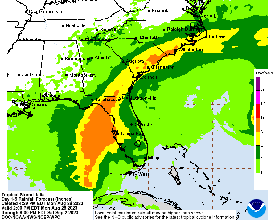
Rainfall amounts will be heaviest along and east of the track of
Idalia, especially in the eastern Florida Big Bend, where 5 to
8 inches of rain are forecast, with isolated higher amounts possible.
This could lead to life threatening flash flooding. The storm should
be moving fast enough to preclude river flooding at this time.
Isolated tornadoes are possible and life-threatening rip currents will
affect beaches well away from the core of the storm.
POTENTIAL IMPACTS
—————–
* SURGE:
Protect against life-threatening surge having possible devastating
impacts across Taylor and Dixie Counties. Potential impacts in this
area include:
– Widespread deep inundation, with storm surge flooding greatly
accentuated by powerful battering waves. Structural damage to
buildings, with many washing away. Damage greatly compounded
from considerable floating debris. Locations may be
uninhabitable for an extended period.
– Near-shore escape routes and secondary roads washed out or
severely flooded. Flood control systems and barriers may become
stressed.
– Extreme beach erosion. New shoreline cuts possible.
– Massive damage to marinas, docks, boardwalks, and piers.
Numerous small craft broken away from moorings with many lifted
onshore and stranded.
Also, protect against life-threatening surge having possible
significant to extensive impacts across Wakulla and Jefferson Counties.
Also, protect against locally hazardous surge having possible limited
impacts across Franklin County.
Elsewhere across eastern Florida panhandle, little to no impact is
anticipated.
* WIND:
Protect against life-threatening wind having possible devastating
impacts across coastal and southeast Florida Big Bend. Potential impacts
in this area include:
– Structural damage to sturdy buildings, some with complete roof
and wall failures. Complete destruction of mobile homes. Damage
greatly accentuated by large airborne projectiles. Locations
may be uninhabitable for weeks or months.
– Numerous large trees snapped or uprooted along with fences and
roadway signs blown over.
– Many roads impassable from large debris, and more within urban
or heavily wooded places. Many bridges, causeways, and access
routes impassable.
– Widespread power and communications outages.
Also, protect against life-threatening wind having possible extensive
impacts across the remainder of the Florida Big Bend into the lower I-75
corridor of Georgia.
* FLOODING RAIN:
Protect against life-threatening rainfall flooding having possible
extensive impacts across the eastern Florida Big Bend and the I-75
corridor of Georgia. Potential impacts include:
– Major rainfall flooding may prompt many evacuations and rescues.
– Rivers and tributaries may rapidly overflow their banks in
multiple places. Small streams, creeks, and ditches may become
dangerous rivers. Flood control systems and barriers may become
stressed.
– Flood waters can enter many structures within multiple
communities, some structures becoming uninhabitable or washed
away. Many places where flood waters may cover escape routes.
Streets and parking lots become rivers of moving water with
underpasses submerged. Driving conditions become dangerous.
Many road and bridge closures with some weakened or washed out.
Protect against dangerous rainfall flooding having possible limited
to significant impacts across the remainder of the Florida Big Bend and
portions of Southwest Georgia.
* TORNADOES:
Protect against a dangerous tornado event having possible significant
impacts across the southeast Florida Big Bend. Potential impacts
include:
– The occurrence of scattered tornadoes can hinder the execution
of emergency plans during tropical events.
– Several places may experience tornado damage with a few spots
of considerable damage, power loss, and communications failures.
– Locations could realize roofs torn off frame houses, mobile
homes demolished, boxcars overturned, large trees snapped or
uprooted, vehicles tumbled, and small boats tossed about.
Dangerous projectiles can add to the toll.
Protect against a tornado event having possible limited impacts
across the remainder of the eastern Florida Big Bend into the I-75
corridor of Georgia.
Elsewhere across eastern Florida panhandle, western Florida Big Bend,
southeastern Alabama and the remainder of southwestern Georgia,
little to no impact is anticipated.
PRECAUTIONARY/PREPAREDNESS ACTIONS
———————————-
* EVACUATIONS:
Listen to local official for recommended preparedness actions,
including possible evacuation. If ordered to evacuate, do so
immediately.
For those not under evacuation orders, assess the risk from wind,
falling trees, and flooding at your location. If you decide to move,
relocate to a safer location nearby. If you do not relocate, help keep
roadways open for those under evacuation orders.
If evacuating, leave with a destination in mind and allow extra time
to get there. Take your emergency supplies kit. Gas up your vehicle
ahead of time.
* OTHER PREPAREDNESS INFORMATION:
Now is the time to complete all preparations to protect life and
property in accordance with your emergency plan. Ensure you are in a
safe location before the onset of strong winds or possible flooding.
If you are relocating to safe shelter, leave as early as possible.
Allow extra time to reach your destination. Many roads and bridges
will be closed once strong winds arrive. Check the latest weather
forecast before departing and drive with caution.
If heading to a community shelter, become familiar with the shelter
rules before arrival, especially if you have special needs or have
pets. Take essential items with you from your Emergency Supplies Kit.
Failure to adequately shelter may result in serious injury or loss of
life. Always heed the advice of local officials and comply with any
orders that are issued. Remember, during the storm 9 1 1 Emergency
Services may not be able to immediately respond if conditions are
unsafe. This should be a big factor in your decision making.
If in a place that is vulnerable to high wind, such as near large
trees, a manufactured home, upper floors of a high-rise building, or on
a boat, consider moving to a safer shelter before the onset of strong
winds or flooding.
* ADDITIONAL SOURCES OF INFORMATION:
– For information on appropriate preparations see ready.gov
– For additional disaster preparedness information see redcross.org
NEXT UPDATE
———–
The next local statement will be issued by the National Weather
Service in Tallahassee FL around 11 PM EDT, or sooner if conditions
warrant.
Be the first to comment