")
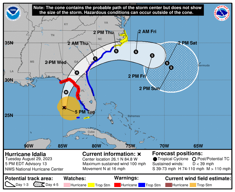
Hurricane Idalia continued to strengthen this afternoon. At 5 PM EDT,
the center of Idalia was located over the eastern Gulf of Mexico about
280 miles south of Saint Marks Florida. Idalia is moving to the north
at 16 mph. Idalia now has top sustained winds of 100 mph. Additional
strengthening is expected through tonight, and Idalia is expected to
be a major hurricane at landfall along the Big Bend coast. Idalia is
expected to be Category 3 hurricane at landfall and could possibly be
a low-end Category 4.
Hurricane Idalia Local Statement Advisory Number 13
National Weather Service Tallahassee FL AL102023
535 PM EDT Tue Aug 29 2023 /435 PM CDT Tue Aug 29 2023/
This product covers eastern Florida panhandle, Florida Big Bend,
southeastern Alabama and southwestern Georgia
…PREPARATIONS FOR EXPECTED MAJOR HURRICANE IDALIA SHOULD BE RUSHED
TO COMPLETION…
NEW INFORMATION
—————
* CHANGES TO WATCHES AND WARNINGS:
– The Tropical Storm Warning has been upgraded to a Hurricane
Warning for Berrien, Cook, and Thomas
– A Tropical Storm Warning has been issued for Baker, Dougherty,
and Lee
* CURRENT WATCHES AND WARNINGS:
– A Storm Surge Warning and Hurricane Warning are in effect for
Coastal Dixie, Coastal Franklin, Coastal Jefferson, Coastal
Taylor, and Coastal Wakulla
– A Hurricane Warning is in effect for Berrien, Brooks, Cook,
Inland Dixie, Inland Jefferson, Inland Taylor, Inland Wakulla,
Lafayette, Lanier, Leon, Lowndes, Madison, and Thomas
– A Tropical Storm Warning is in effect for Baker, Ben Hill,
Coastal Gulf, Colquitt, Decatur, Dougherty, Gadsden, Grady,
Inland Franklin, Inland Gulf, Irwin, Lee, Liberty, Mitchell,
Tift, Turner, and Worth
* STORM INFORMATION:
– About 300 miles south of Tallahassee or about 270 miles
south-southwest of Keaton Beach
– 26.1N 84.8W
– Storm Intensity 100 mph
– Movement North or 360 degrees at 16 mph
SITUATION OVERVIEW
——————
Preparations in advance of Hurricane Idalia should be rushed to
completion by sunset this evening.
Hurricane Idalia continued to strengthen this afternoon. At 5 PM EDT,
the center of Idalia was located over the eastern Gulf of Mexico about
280 miles south of Saint Marks Florida. Idalia is moving to the north
at 16 mph. Idalia now has top sustained winds of 100 mph. Additional
strengthening is expected through tonight, and Idalia is expected to
be a major hurricane at landfall along the Big Bend coast. Idalia is
expected to be Category 3 hurricane at landfall and could possibly be
a low-end Category 4.
To put this into historical context, there are NO major hurricanes in
the historical dataset going back to 1851 that have tracked into
Apalachee Bay. This has the makings of an unprecedented event for this
part of the state.
Your final preparations should be rushed to completion by sunset this
evening. If you are under an evacuation order, leave as soon as
possible. Conditions will rapidly deteriorate late tonight and early
Wednesday morning.
Life-threatening and catastrophic storm surge is expected around the
shores of Apalachee Bay. From the Aucilla River to Yankeetown, storm
surge inundation of 10 to 15 feet is possible. Storm surge will be
highly dependent on the storm track, with the highest surge values
along and to the right of where the center makes landfall. Storm surge
will peak tonight and Wednesday.
A Storm Surge Warning is in effect from Indian Pass to the Suwannee
River for the danger of life threatening inundation from rising water
moving inland. Storm surge inundation above normally dry ground could
reach the following heights, if the peak surge occurs with high tide:
1 to 3 feet from Mexico Beach to Indian Pass, 3 to 5 feet from Indian
Pass to Carrabelle, 4 to 7 feet from Carrabelle to the mouth of the
Ochlockonee River, 7 to 11 feet from the Ochlockonee River to the
Aucilla River, and 10 to 15 feet from the Aucilla River to the
Suwannee River. The deepest water will occur along the immediate
coast, where the surge will be accompanied by large and dangerous
waves.
A Hurricane Warning is in effect along the coast from Indian Pass to
the Suwannee River, plus inland portions of the Florida Big Bend and
the I-75 corridor of south Georgia. A Tropical Storm Warning is in
effect from Mexico Beach to Indian Pass, plus inland portions of
Southwest Georgia as far northwest as Bainbridge, Camilla, and
Sylvester.
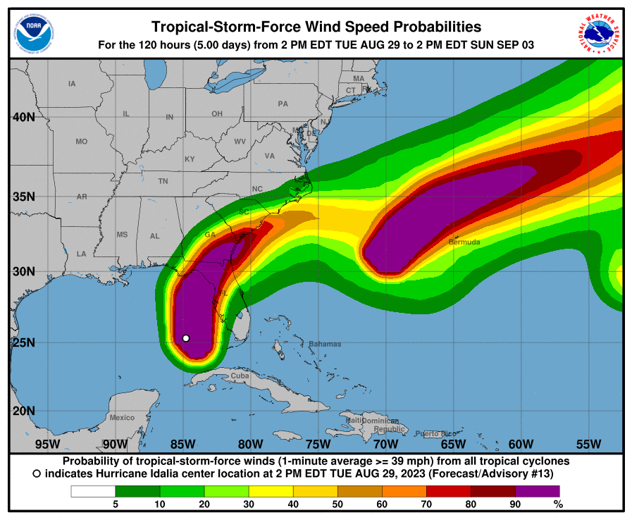
Tropical storm force winds are most likely to arrive along the coast
after midnight tonight, though brief increases to tropical storm force
in rain bands are possible starting early this evening. Preparations
for Idalia need to be rushed to completion. Expect downed trees and
powerlines, possibly widespread in the Big Bend region, with prolonged
power outages possible. Ensure you have enough supplies to last for
several days.
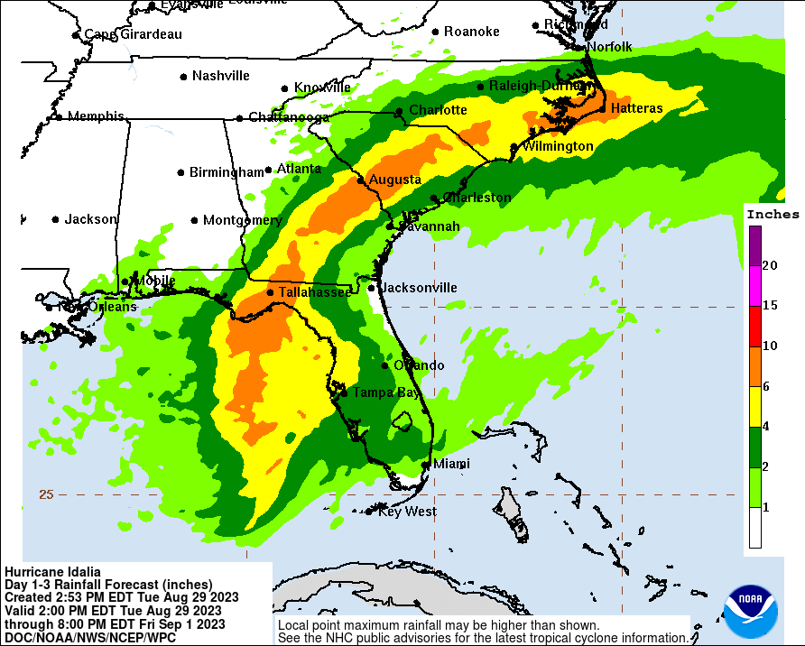
Rainfall amounts will be heaviest along and east of the track of
Idalia, especially in the Florida Big Bend int south-central Georgia.
5 to 8 inches of rain are forecast, with isolated higher amounts
possible. This could lead to life threatening flash flooding. A Flood
Watch is now in effect from Gulf County, FL to Lee County, GA and all
points eastward. River flooding is possible in the Ochlockonee,
Aucilla, Saint Marks, and Suwannee basins, but fast forward motion of
the storms will keep river flooding minor.
Several tornadoes are possible in the outer rain bands starting
tonight and continuing into Wednesday. This will primarily be north
and east of the center.
Life-threatening rip currents and high surf are expected along all
beaches for at least the next couple days, well away from the center.
Everyone needs to stay out of the water.
POTENTIAL IMPACTS
—————–
* SURGE:
Protect against life-threatening surge having possible catastrophic
impacts across the Big Bend coast. Potential impacts in this area
include:
– Widespread deep inundation, with storm surge flooding greatly
accentuated by powerful battering waves. Structural damage to
buildings, with many washing away. Damage greatly compounded
from considerable floating debris. Locations may be
uninhabitable for an extended period.
– Near-shore escape routes and secondary roads washed out or
severely flooded. Flood control systems and barriers may become
stressed.
– Extreme beach erosion. New shoreline cuts possible.
– Massive damage to marinas, docks, boardwalks, and piers.
Numerous small craft broken away from moorings with many lifted
onshore and stranded.
Elsewhere across eastern Florida panhandle little to no impact is
anticipated.
* WIND:
Protect against life-threatening wind having possible devastating
impacts across the Florida Big Bend region and south-central Georgia.
Potential impacts in this area include:
– Structural damage to sturdy buildings, some with complete roof
and wall failures. Complete destruction of mobile homes. Damage
greatly accentuated by large airborne projectiles. Locations
may be uninhabitable for weeks or months.
– Numerous large trees snapped or uprooted along with fences and
roadway signs blown over.
– Many roads impassable from large debris, and more within urban
or heavily wooded places. Many bridges, causeways, and access
routes impassable.
– Widespread power and communications outages.
* FLOODING RAIN:
Areas of flash and urban flooding, some of which may be locally
significant, are expected across portions of the Florida Big Bend, the
eastern Panhandle, and southern Georgia through Wednesday.
* TORNADOES:
A few tornadoes will be possible over the Florida Big Bend tonight, and
spreading into south Georgia Wednesday. Potential impacts include:
– The occurrence of scattered tornadoes can hinder the execution
of emergency plans during tropical events.
– Several places may experience tornado damage with a few spots
of considerable damage, power loss, and communications failures.
– Locations could realize roofs torn off frame houses, mobile homes
demolished, boxcars overturned, large trees snapped or uprooted,
vehicles tumbled, and small boats tossed about. Dangerous
projectiles can add to the toll.
Elsewhere across eastern Florida panhandle and southeastern Alabama,
little to no impact is anticipated.
PRECAUTIONARY/PREPAREDNESS ACTIONS
———————————-
* EVACUATIONS:
Listen to local official for recommended preparedness actions,
including possible evacuation. If ordered to evacuate, do so
immediately.
For those not under evacuation orders, assess the risk from wind,
falling trees, and flooding at your location. If you decide to move,
relocate to a safer location nearby. If you do not relocate, help keep
roadways open for those under evacuation orders.
If evacuating, leave with a destination in mind and allow extra time
to get there. Take your emergency supplies kit. Gas up your vehicle
ahead of time.
Let others know where you are going prior to departure. Secure loose
items and pets in the car, and avoid distracted driving.
If evacuating, follow designated evacuation routes. Seek traffic
information on roadway signs, the radio, and from official sources.
* OTHER PREPAREDNESS INFORMATION:
All preparations to protect life and property should be rushed to
completion. Ensure you are in a safe location before the onset of
strong winds or possible flooding.
If you are relocating to safe shelter, leave as early as possible.
Allow extra time to reach your destination. Many roads and bridges
will be closed once strong winds arrive. Check the latest weather
forecast before departing and drive with caution.
If heading to a community shelter, become familiar with the shelter
rules before arrival, especially if you have special needs or have
pets. Take essential items with you from your Emergency Supplies Kit.
Failure to adequately shelter may result in serious injury or loss of
life. Always heed the advice of local officials and comply with any
orders that are issued. Remember, during the storm 9 1 1 Emergency
Services may not be able to immediately respond if conditions are
unsafe. This should be a big factor in your decision making.
Keep cell phones well charged. Cell phone chargers for automobiles
can be helpful, but be aware of your risk for deadly carbon monoxide
poisoning if your car is left idling in a garage or other poorly
ventilated area.
If you are a visitor, be sure to know the name of the city in which
you are staying and the name of the county in which it resides.
Listen for these locations in local news updates. Pay attention for
instructions from local authorities.
Storm surge is the leading killer associated with tropical storms and
hurricanes! Make sure you are in a safe area away from the surge
zone. Even if you are not in a surge-prone area, you could find
yourself cutoff by flood waters during and after the storm. Heed
evacuation orders issued by the local authorities.
Rapidly rising flood waters are deadly. If you are in a flood-prone
area, consider moving to higher ground. Never drive through a flooded
roadway. Remember, turn around don`t drown!
If a Tornado Warning is issued for your area, be ready to shelter
quickly, preferably away from windows and in an interior room not
prone to flooding. If driving, scan the roadside for quick shelter
options.
If in a place that is vulnerable to high wind, such as near large
trees, a manufactured home, upper floors of a high-rise building, or
on a boat, consider moving to a safer shelter before the onset of
strong winds or flooding.
Closely monitor weather.gov, NOAA Weather radio or local news outlets
for official storm information. Be ready to adapt to possible changes
to the forecast. Ensure you have multiple ways to receive weather
warnings.
* ADDITIONAL SOURCES OF INFORMATION:
– For information on appropriate preparations see ready.gov
– For additional disaster preparedness information see redcross.org
NEXT UPDATE
———–
The next local statement will be issued by the National Weather
Service in Tallahassee FL around 1130 PM EDT, or sooner if conditions
warrant.
$$
Be the first to comment