")
Hurricane Local Statement
Tropical Storm Idalia Local Statement Advisory Number 6
ALZ065>069-FLZ007>019-026>029-034-108-112-114-115-118-127-128-134-GAZ120>131-142>148-155>161-281115-
Tropical Storm Idalia Local Statement Advisory Number 6
National Weather Service Tallahassee FL AL102023
1114 PM EDT Sun Aug 27 2023 /1014 PM CDT Sun Aug 27 2023/
This product covers eastern Florida panhandle, Florida Big Bend, southeastern Alabama and southwestern Georgia
…IDALIA STRENGTHENING QUICKLY…
NEW INFORMATION
—————
* CHANGES TO WATCHES AND WARNINGS:
– None
* CURRENT WATCHES AND WARNINGS:
– A Storm Surge Watch and Hurricane Watch are in effect for
Coastal Dixie, Coastal Franklin, Coastal Jefferson, Coastal
Taylor, and Coastal Wakulla
– A Hurricane Watch is in effect for Inland Dixie, Inland Taylor,
and Lafayette
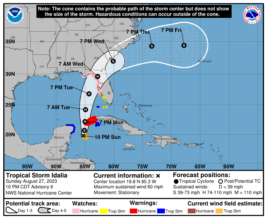
* STORM INFORMATION:
– About 710 miles south of Panama City or about 680 miles south
of Apalachicola
– 19.8N 85.3W
– Storm Intensity 60 mph
– Movement Stationary
SITUATION OVERVIEW
——————
Tropical Storm Idalia underwent strengthening on Sunday evening,
while meandering over the far northwest Caribbean Sea.
At 11 PM EDT, the center of Idalia was located about 710 miles south
of Saint Marks, Florida. Maximum sustained winds had increased to
60 mph.
On Monday, Idalia is expected to start moving generally northward
while increasing its forward speed. Idalia is expected to become a
hurricane on Monday over the southeast Gulf. Idalia will continue to
strengthen on Tuesday while moving northward or north-northeastward
over the eastern Gulf. Idalia is forecast to make landfall later
Tuesday night along the northeast Gulf Coast.
The most significant impact will be the potential for life-
threatening storm surge around the shores of Apalachee Bay. Storm
surge will be highly dependent on the storm track, with the highest
surge values along and to the right of the center. Storm surge could
start to build as soon as Tuesday afternoon, with peak surge values
coming on Tuesday night and Wednesday.
A Storm Surge Watch has been issued for the possibility of life
threatening inundation from rising water moving inland for much of
Apalachee Bay, from Indian Pass to the Suwannee River. Storm surge
inundation above normally dry ground could reach the following
heights, if the peak surge occurs with high tide: 2 to 4 feet from
Indian Pass to the Ochlockonee River, 4 to 7 feet from the Ochlockonee
River to the Aucilla River, and 7 to 11 feet from the Aucilla River to
the Suwannee River. The deepest water will occur along the immediate
coast, where the surge will be accompanied by large and dangerous
waves.
In addition, the odds of hurricane force winds are increasing over the
southeast Big Bend Region, and the forecast hurricane intensity at
landfall has increased since the last advisory. Idalia is now forecast
to be nearing major hurricane status at landfall. A Hurricane Watch is
in effect from Indian Pass to the Suwannee River, including inland
portions of Taylor, Dixie and Lafayette Counties.
Flooding from heavy rainfall and an isolated tornado are possible.
Life-threatening rip currents will affect beaches well away from the
core of the storm.
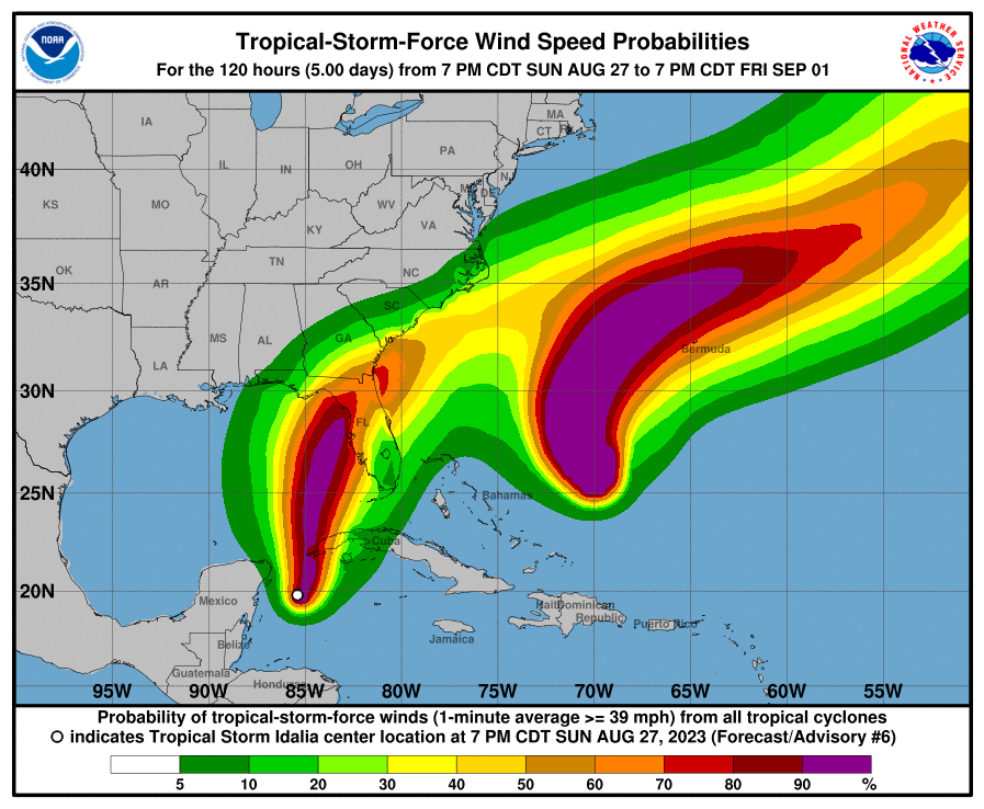
Tropical storm force winds are most likely to arrive along the coast
on Tuesday evening, but they could arrive as early as Tuesday
afternoon. It is recommended that preparations for Idalia be completed
before sunset on Tuesday, if not sooner. Expect downed trees and
powerlines, with prolonged power outages possible.
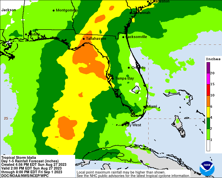
Rainfall amounts will be heaviest along and east of the track of
Idalia, especially in the Florida Big Bend, where 4 to 8 inches of
rain are forecast, with isolated higher amounts possible. This could
lead to flash flooding. The storm should be moving fast enough to
preclude river flooding at this time.
POTENTIAL IMPACTS
—————–
* SURGE:
Prepare for life-threatening surge having possible devastating
impacts across Taylor and Dixie Counties. Potential impacts in
this area include:
– Widespread deep inundation, with storm surge flooding greatly
accentuated by powerful battering waves. Structural damage to
buildings, with many washing away. Damage greatly compounded
from considerable floating debris. Locations may be
uninhabitable for an extended period.
– Near-shore escape routes and secondary roads washed out or
severely flooded. Flood control systems and barriers may become
stressed.
– Extreme beach erosion. New shoreline cuts possible.
– Massive damage to marinas, docks, boardwalks, and piers.
Numerous small craft broken away from moorings with many lifted
onshore and stranded.
Also, prepare for life-threatening surge having possible significant
to extensive impacts across Wakulla and Jefferson Counties.
Also, prepare for locally hazardous surge having possible limited
impacts across Franklin and Gulf Counties.
Elsewhere across eastern Florida Panhandle, little to no impact is
anticipated.
* WIND:
Prepare for life-threatening wind having possible extensive impacts
across the coastal Florida Big Bend. Potential impacts in this area
include:
– Considerable roof damage to sturdy buildings, with some having
window, door, and garage door failures leading to structural
damage. Mobile homes severely damaged, with some destroyed.
Damage accentuated by airborne projectiles. Locations may be
uninhabitable for weeks.
– Many large trees snapped or uprooted along with fences and
roadway signs blown over.
– Some roads impassable from large debris, and more within urban
or heavily wooded places. Several bridges, causeways, and
access routes impassable.
– Large areas with power and communications outages.
Also, prepare for dangerous wind having possible limited to
significant impacts across inland portions of the Florida Big Bend.
* FLOODING RAIN:
Prepare for dangerous rainfall flooding having possible significant
impacts across portions of southeast Alabama, southwest Georgia, the
Florida Big Bend, and eastern Florida Panhandle. Potential impacts
include:
– Moderate rainfall flooding may prompt several evacuations and
rescues.
– Rivers and tributaries may quickly become swollen with swifter
currents and overspill their banks in a few places, especially
in usually vulnerable spots. Small streams, creeks, and ditches
overflow.
– Flood waters can enter some structures or weaken foundations.
Several places may experience expanded areas of rapid
inundation at underpasses, low-lying spots, and poor drainage
areas. Some streets and parking lots take on moving water as
storm drains and retention ponds overflow. Driving conditions
become hazardous. Some road and bridge closures.
* TORNADOES:
Prepare for a tornado event having possible limited impacts across the
southeast Florida Big Bend. Potential impacts include:
– The occurrence of isolated tornadoes can hinder the execution
of emergency plans during tropical events.
– A few places may experience tornado damage, along with power
and communications disruptions.
– Locations could realize roofs peeled off buildings, chimneys
toppled, mobile homes pushed off foundations or overturned,
large tree tops and branches snapped off, shallow-rooted trees
knocked over, moving vehicles blown off roads, and small boats
pulled from moorings.
Elsewhere across eastern Florida panhandle, Florida Big Bend,
southeastern Alabama and southwestern Georgia, little to no impact is
anticipated.
PRECAUTIONARY/PREPAREDNESS ACTIONS
———————————-
* EVACUATIONS:
Listen to local official for recommended preparedness actions,
including possible evacuation. If ordered to evacuate, do so
immediately.
For those not under evacuation orders, assess the risk from wind,
falling trees, and flooding at your location. If you decide to move,
relocate to a safer location nearby. If you do not relocate, help
keep roadways open for those under evacuation orders.
If evacuating, leave with a destination in mind
and allow extra time to get there. Take your emergency supplies kit.
Gas up your vehicle ahead of time.
* OTHER PREPAREDNESS INFORMATION:
Now is the time to check your emergency plan and emergency supplies
kit and take necessary actions to protect your family and secure your
home or business.
When making safety and preparedness decisions, do not focus on the
exact forecast track since hazards such as flooding rain, damaging
wind gusts, storm surge, and tornadoes extend well away from the
center of the storm.
If in a place that is vulnerable to high wind, such as near large
trees, a manufactured home, upper floors of a high-rise building, or
on a boat, plan to move to safe shelter.
If you live in a place particularly vulnerable to flooding, such as
near the Gulf of Mexico or a large inland lake, in a low-lying or
poor drainage area, or near an already swollen river, plan to move to
safe shelter on higher ground.
Always heed the advice of local officials and comply with orders that
are issued. Do not needlessly jeopardize your life or the lives of
others.
Check on those who may not be fully aware of the situation or who are
unable to make personal preparations.
Closely monitor weather.gov, NOAA Weather Radio and local news
outlets for official storm information. Listen for possible changes
to the forecast.
* ADDITIONAL SOURCES OF INFORMATION:
– For information on appropriate preparations see ready.gov
– For additional disaster preparedness information see redcross.org
NEXT UPDATE
———–
The next local statement will be issued by the National Weather
Service in Tallahassee FL around 5 AM EDT, or sooner if conditions
warrant.
$$
Be the first to comment