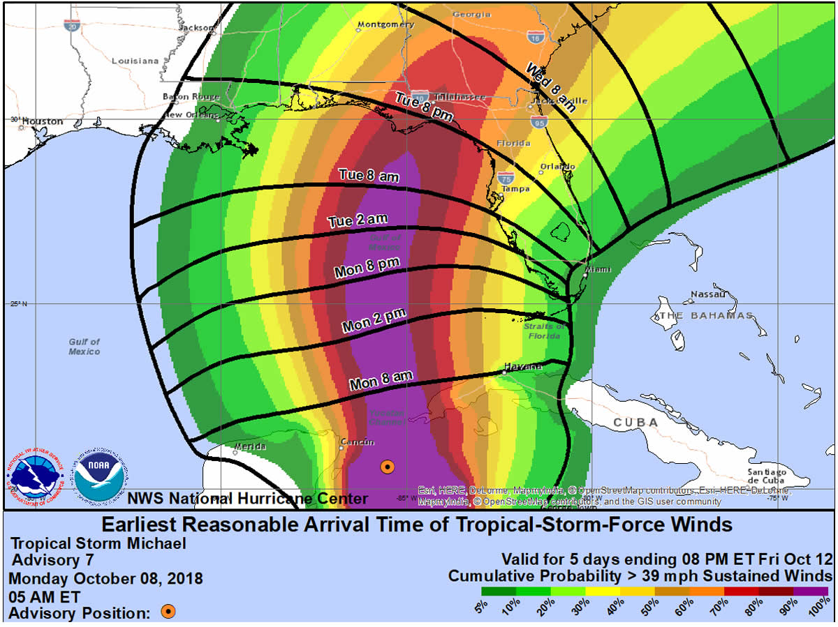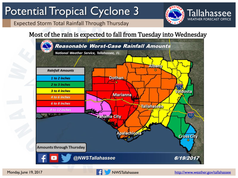
The National Weather Service in Tallahassee has officially announced a Hurricane Watch is in effect for all of the Florida Panhandle, Southeast Alabama and Southwest Georgia. Tropical Storm Michael strengthened overnight and is expected to continue to build into a hurricane before making landfall on the Gulf Coast. Southwest Georgia is predicted to see significant impacts from the storm and could see Tropical Storm force winds as early as Tuesday evening.

Hurricane Watch
Michael Local Watch/Warning Statement/Advisory Number 7
National Weather Service Tallahassee FL  AL142018
516 AM EDT Mon Oct 8 2018

GAZ156-081730-
/O.NEW.KTAE.HU.A.1014.181008T0916Z-000000T0000Z/
Decatur-
516 AM EDT Mon Oct 8 2018

...HURRICANE WATCH IN EFFECT...

A Hurricane Watch means hurricane-force winds are possible somewhere
within this area within the next 48 hours

* LOCATIONS AFFECTED
    - Bainbridge

* WIND
    - LATEST LOCAL FORECAST: Equivalent Strong Tropical Storm force
      wind
        - Peak Wind Forecast: 45-60 mph with gusts to 75 mph
        - Window for Tropical Storm force winds: Wednesday morning
          until Thursday morning

    - POTENTIAL THREAT TO LIFE AND PROPERTY: Potential for wind 74 to
      110 mph
        - PLAN: Plan for life-threatening wind of equivalent CAT 1 or
          2 hurricane force due to possible forecast changes in
          track, size, or intensity.
        - PREPARE: Efforts to protect life and property should now be
          rigorously underway. Prepare for considerable wind damage.
        - ACT: Act now to complete preparations before the wind
          becomes hazardous.

    - POTENTIAL IMPACTS: Extensive
        - Considerable roof damage to sturdy buildings, with some
          having window, door, and garage door failures leading to
          structural damage. Mobile homes severely damaged, with some
          destroyed. Damage accentuated by airborne projectiles.
          Locations may be uninhabitable for weeks.
        - Many large trees snapped or uprooted along with fences and
          roadway signs blown over.
        - Some roads impassable from large debris, and more within
          urban or heavily wooded places. Several bridges, causeways,
          and access routes impassable.
        - Large areas with power and communications outages.

* FLOODING RAIN
    - LATEST LOCAL FORECAST:
        - Peak Rainfall Amounts: 6-10 inches, with locally higher
          amounts

    - POTENTIAL THREAT TO LIFE AND PROPERTY: Potential for localized
      flooding rain
        - PLAN: Emergency plans should include the potential for
          localized flooding from heavy rain.
        - PREPARE: Consider protective actions if you are in an area
          vulnerable to flooding.
        - ACT: Heed any flood watches and warnings.

    - POTENTIAL IMPACTS: Limited
        - Localized rainfall flooding may prompt a few evacuations.
        - Rivers and tributaries may quickly rise with swifter
          currents. Small streams, creeks, and ditches may become
          swollen and overflow in spots.
        - Flood waters can enter a few structures, especially in
          usually vulnerable spots. A few places where rapid ponding
          of water occurs at underpasses, low-lying spots, and poor
          drainage areas. Several storm drains and retention ponds
          become near-full and begin to overflow. Some brief road and
          bridge closures.

* TORNADO
    - LATEST LOCAL FORECAST:
        - Situation is somewhat favorable for tornadoes

    - POTENTIAL THREAT TO LIFE AND PROPERTY: Potential for a few
      tornadoes
        - PLAN: Emergency plans should include the potential for a
          few tornadoes.
        - PREPARE: If your shelter is particularly vulnerable to
          tornadoes, prepare to relocate to safe shelter before
          hazardous weather arrives.
        - ACT: If a tornado warning is issued, be ready to shelter
          quickly.

    - POTENTIAL IMPACTS: Limited
        - The occurrence of isolated tornadoes can hinder the
          execution of emergency plans during tropical events.
        - A few places may experience tornado damage, along with
          power and communications disruptions.
        - Locations could realize roofs peeled off buildings,
          chimneys toppled, mobile homes pushed off foundations or
          overturned, large tree tops and branches snapped off,
          shallow-rooted trees knocked over, moving vehicles blown
          off roads, and small boats pulled from moorings.

* FOR MORE INFORMATION:
    - Local Weather Conditions and Forecasts: NWS Tallahassee
        - https://www.weather.gov/tallahassee
    - Information from the Georgia Emergency Management Agency
        - https://ready.ga.gov
Hurricane Local Statement
Tropical Storm Michael Local Statement Advisory Number 7
ALZ065>069-FLZ007>019-026>029-034-108-112-114-115-118-127-128-134-GAZ120>131-142>148-155>161-081745-

Tropical Storm Michael Local Statement Advisory Number 7
National Weather Service Tallahassee FL  AL142018
543 AM EDT Mon Oct 8 2018 /443 AM CDT Mon Oct 8 2018/

This product covers EASTERN FLORIDA PANHANDLE...FLORIDA BIG BEND...SOUTHEASTERN ALABAMA AND SOUTHWESTERN GEORGIA

**MICHAEL EXPECTED TO BRING A POTENTIALLY LIFE-THREATENING SITUATION TO THE NORTHERN GULF COAST**

NEW INFORMATION
---------------

* CHANGES TO WATCHES AND WARNINGS:
    - A Storm Surge Watch and Hurricane Watch have been issued for
      Coastal Bay, Coastal Dixie, Coastal Franklin, Coastal Gulf,
      Coastal Jefferson, Coastal Taylor, Coastal Wakulla, Inland
      Franklin, Inland Gulf, Inland Wakulla, and South Walton
    - A Hurricane Watch has been issued for Calhoun, Central Walton,
      Decatur, Gadsden, Grady, Holmes, Inland Bay, Inland Dixie,
      Inland Jefferson, Inland Taylor, Jackson, Leon, Liberty, North
      Walton, Seminole, and Washington
    - A Tropical Storm Watch has been issued for Baker, Ben Hill,
      Berrien, Brooks, Calhoun, Clay, Coffee, Colquitt, Cook, Dale,
      Dougherty, Early, Geneva, Henry, Houston, Irwin, Lafayette,
      Lanier, Lee, Lowndes, Madison, Miller, Mitchell, Quitman,
      Randolph, Terrell, Thomas, Tift, Turner, and Worth

* CURRENT WATCHES AND WARNINGS:
    - A Storm Surge Watch and Hurricane Watch are in effect for
      Coastal Bay, Coastal Dixie, Coastal Franklin, Coastal Gulf,
      Coastal Jefferson, Coastal Taylor, Coastal Wakulla, Inland
      Franklin, Inland Gulf, Inland Wakulla, and South Walton
    - A Hurricane Watch is in effect for Calhoun, Central Walton,
      Decatur, Gadsden, Grady, Holmes, Inland Bay, Inland Dixie,
      Inland Jefferson, Inland Taylor, Jackson, Leon, Liberty, North
      Walton, Seminole, and Washington
    - A Tropical Storm Watch is in effect for Baker, Ben Hill,
      Berrien, Brooks, Calhoun, Clay, Coffee, Colquitt, Cook, Dale,
      Dougherty, Early, Geneva, Henry, Houston, Irwin, Lafayette,
      Lanier, Lee, Lowndes, Madison, Miller, Mitchell, Quitman,
      Randolph, Terrell, Thomas, Tift, Turner, and Worth

* STORM INFORMATION:
    - About 660 miles south of PANAMA CITY or about 630 miles south
      of APALACHICOLA
    - 20.6N 85.5W
    - Storm Intensity 70 mph
    - Movement North or 360 degrees at 7 mph

SITUATION OVERVIEW
------------------

A potentially life-threatening weather situation is shaping up as Tropical
Storm Michael tracks towards the northern Gulf coast. Tropical Storm Michael
was located off the Yucatan Peninsula this morning and will continue to move
northward to the northern Gulf coast over the next few days. The
potential exists for Michael to be a major hurricane before landfall. With
landfall expected along the Florida Panhandle or Big Bend coast,
significant impacts are expected across the area with impacts beginning
late Tuesday to early Wednesday. These will include the possibility of
life-threatening storm surge, widespread power outages, downed trees,
structural damage, isolated flash flooding and the potential for a few
tornadoes.

POTENTIAL IMPACTS
-----------------

* SURGE:
Prepare for life-threatening surge having possible devastating
impacts across the Apalachee Bay coastline. Potential impacts in
this area include:
    - Widespread deep inundation, with storm surge flooding greatly
      accentuated by powerful battering waves. Structural damage to
      buildings, with many washing away. Damage greatly compounded
      from considerable floating debris. Locations may be
      uninhabitable for an extended period.
    - Near-shore escape routes and secondary roads washed out or
      severely flooded. Flood control systems and barriers may become
      stressed.
    - Extreme beach erosion. New shoreline cuts possible.
    - Massive damage to marinas, docks, boardwalks, and piers.
      Numerous small craft broken away from moorings with many lifted
      onshore and stranded.

Also, prepare for life-threatening surge having possible significant
to extensive impacts across the Florida Panhandle.

* WIND:
Prepare for life-threatening wind having possible extensive impacts
across EASTERN FLORIDA PANHANDLE...FLORIDA BIG BEND...SOUTHEASTERN
ALABAMA AND SOUTHWESTERN GEORGIA. Potential impacts include:
    - Considerable roof damage to sturdy buildings, with some having
      window, door, and garage door failures leading to structural
      damage. Mobile homes severely damaged, with some destroyed.
      Damage accentuated by airborne projectiles. Locations may be
      uninhabitable for weeks.
    - Many large trees snapped or uprooted along with fences and
      roadway signs blown over.
    - Some roads impassable from large debris, and more within urban
      or heavily wooded places. Several bridges, causeways, and
      access routes impassable.
    - Large areas with power and communications outages.

* FLOODING RAIN:
Prepare for locally hazardous rainfall flooding having possible
limited impacts across EASTERN FLORIDA PANHANDLE...FLORIDA BIG
BEND...SOUTHEASTERN ALABAMA AND SOUTHWESTERN GEORGIA. Potential
impacts include:
    - Localized rainfall flooding may prompt a few evacuations.
    - Rivers and tributaries may quickly rise with swifter currents.
      Small streams, creeks, and ditches may become swollen and
      overflow in spots.
    - Flood waters can enter a few structures, especially in usually
      vulnerable spots. A few places where rapid ponding of water
      occurs at underpasses, low-lying spots, and poor drainage
      areas. Several storm drains and retention ponds become
      near-full and begin to overflow. Some brief road and bridge
      closures.

* TORNADOES:
Prepare for a tornado event having possible limited impacts across
EASTERN FLORIDA PANHANDLE...FLORIDA BIG BEND...SOUTHEASTERN ALABAMA
AND SOUTHWESTERN GEORGIA. Potential impacts include:
    - The occurrence of isolated tornadoes can hinder the execution
      of emergency plans during tropical events.
    - A few places may experience tornado damage, along with power
      and communications disruptions.
    - Locations could realize roofs peeled off buildings, chimneys
      toppled, mobile homes pushed off foundations or overturned,
      large tree tops and branches snapped off, shallow-rooted trees
      knocked over, moving vehicles blown off roads, and small boats
      pulled from moorings.

* OTHER COASTAL HAZARDS:
In addition, strong winds and high surf will result in deadly rip currents
with the greatest chances Tuesday and Wednesday.

PRECAUTIONARY/PREPAREDNESS ACTIONS
----------------------------------

* EVACUATIONS:
Listen to local official for recommended preparedness actions, including
possible evacuation. If ordered to evacuate, do so immediately.

For those not under evacuation orders, assess the risk from wind, falling
trees, and flooding at your location. If you decide to move, relocate to a
safer location nearby. If you do not relocate, help keep roadways open for
those under evacuation orders.

* OTHER PREPAREDNESS INFORMATION:
Now is the time to check your emergency plan and emergency supplies
kit and take necessary actions to protect your family and secure your
home or business.

When making safety and preparedness decisions, do not focus on the
exact forecast track since hazards such as flooding rain, damaging
wind gusts, storm surge, and tornadoes extend well away from the
center of the storm.

If in a place that is vulnerable to high wind, such as near large
trees, a manufactured home, upper floors of a high-rise building, or
on a boat, plan to move to safe shelter.

If you live in a place particularly vulnerable to flooding, such as
near the Gulf of Mexico or a large inland lake, in a low-lying or
poor drainage area, or near an already swollen river, plan to move to
safe shelter on higher ground.

Closely monitor weather.gov, NOAA Weather Radio and local news
outlets for official storm information. Listen for possible changes
to the forecast.

* ADDITIONAL SOURCES OF INFORMATION:
- For information on appropriate preparations see ready.gov
- For additional disaster preparedness information see redcross.org

NEXT UPDATE
-----------

The next local statement will be issued by the National Weather
Service in Tallahassee FL around 11:30 AM EDT, or sooner if
conditions warrant.


Be the first to comment