Michael is continues to strengthen and is now a strong category 4 hurricane with maximum sustained winds of 130 mph.
Additional strengthening is likely and Michael is expected to be a major category 4 hurricane later this morning and at landfall on Wednesday.
This is a storm of unprecedented strength for this area.All available means should be used to implore people to evacuate.
Hurricane Warnings remain in effect for much of the region.Tropical Storm warnings surround the hurricane warning area.
Tropical storm conditions will begin to affect the area within a couple of hours from now. Hurricane conditions could begin as early as sunrise.
Significant and life threatening storm surge is possible with Michael, especially in Apalachee Bay.
Locally heavy rainfall could cause flash flooding beginning today.
10/9/2018 11:58 PM www.weather.gov/Tallahassee
Situation Overview
Tallahassee WEATHER FORECAST OFFICE
Hurricane Michael
Michael is a strong category 3 hurricane with maximum sustained winds of 125 mph. Category 4 is now forecast.
Hurricane and Storm Surge Warnings remain in effect
Significant impacts expected!
NOTE: Do not focus on the exact track. Impacts can occur well outside the area enclosed by the cone.
10/9/2018 11:58 PM
www.weather.gov/Tallahassee
Current SatelliteView
Tallahassee WEATHER FORECAST OFFICE
Hurricane Michael
10/9/2018 11:58 PM www.weather.gov/Tallahassee
Wind Speed Probabilities
Tallahassee WEATHER FORECAST OFFICE
Hurricane Michael
There’s a near certainty of tropical storm conditions for most points.
10/9/2018 11:58 PM www.weather.gov/Tallahassee
Wind Speed Probabilities
Tallahassee WEATHER FORECAST OFFICE
Hurricane Michael
There’s a near certainty of hurricane conditions along the coast for points from Panama City to Indian Pass
There’s a 7 in 10 chance of hurricane conditions across interior points of the Florida Panhandle from Washington County eastward to Gadsden County Florida as well as into Southwestern Georgia.
There’s a 1 in 3 chance of hurricane conditions as far inland as Albany.
10/9/2018 11:58 PM
www.weather.gov/Tallahassee
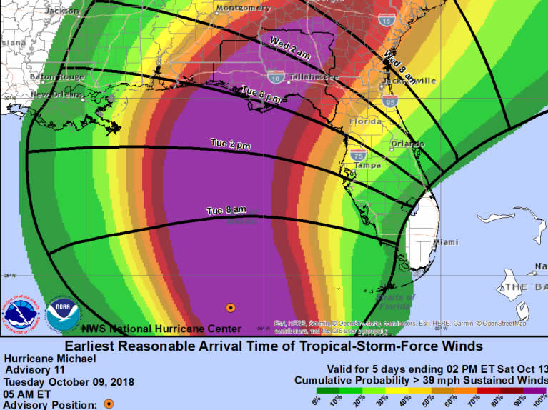
Earliest Arrival Time of TS Winds
Tallahassee WEATHER FORECAST OFFICE
Hurricane Michael
10/9/2018 11:58 PM www.weather.gov/Tallahassee
Most Likely Arrival of TS Winds
Tallahassee WEATHER FORECAST OFFICE
Hurricane Michael
10/9/2018 11:58 PM www.weather.gov/Tallahassee
Departure Time of TS Winds
Tallahassee WEATHER FORECAST OFFICE
Hurricane Michael
10/9/2018 11:58 PM www.weather.gov/Tallahassee
Potential Peak Gusts
Tallahassee WEATHER FORECAST OFFICE
Hurricane Michael
10/9/2018 11:58 PM www.weather.gov/Tallahassee
Wind Threat / Potential Impact
Tallahassee WEATHER FORECAST OFFICE
Hurricane Michael
10/9/2018 11:58 PM www.weather.gov/Tallahassee
Wind Threat / Potential Impact
Tallahassee WEATHER FORECAST OFFICE
Hurricane Michael
10/9/2018 11:58 PM www.weather.gov/Tallahassee
Potential Storm Surge Flooding
Tallahassee WEATHER FORECAST OFFICE
Hurricane Michael
Potential for significant and life threatening storm surge.
Locations of greatest risk:
Florida Panhandle: 6 to 8 feet above
ground.
Gulf County through Franklin County 8 to 10 feet above ground.
Wakulla County through Taylor County 10 to 12 feet above ground.
Dixie County 8 to 10 feet above ground.
Timing: Storm surge inundation could begin as early as Tuesday night, peaking on Wednesday.
Note: This graphic shows where storm surge could occur. It depicts a reasonable worst case scenario and not inland extent.
10/9/2018 11:58 PM
www.weather.gov/Tallahassee
Storm Surge Watch/Warning
Tallahassee WEATHER FORECAST OFFICE
Hurricane Michael
Storm Surge Warning Storm Surge Watch
10/9/2018 11:58 PM
www.weather.gov/Tallahassee
Expected Storm Total Rainfall
Tallahassee WEATHER FORECAST OFFICE
Hurricane Michael
Storm total rainfall forecast valid Wednesday and Thursday Note:There will likely be locally higher amounts
10/9/2018 11:58 PM
www.weather.gov/Tallahassee
Potential Tornado Impacts
Tallahassee WEATHER FORECAST OFFICE
Hurricane Michael
Main threat of tornadoes would be beginning on Wednesday and continuing into Thursday.
10/9/2018 11:58 PM www.weather.gov/Tallahassee
Summary
Tallahassee WEATHER FORECAST OFFICE
Hurricane Michael
Michael is continues to strengthen and is now a strong category 3 hurricane with maximum sustained winds of 125 mph.
Additional strengthening is likely and Michael is expected to be a major category 4 hurricane later this morning and at landfall on Wednesday.
This is a storm of unprecedented strength for this area.All available means should be used to implore people to evacuate.
Hurricane Warnings remain in effect for much of the region.Tropical Storm warnings surround the hurricane warning area.
Tropical storm conditions will begin to affect the area within a couple of hours from now. Hurricane conditions could begin as early as sunrise.
Significant and life threatening storm surge is possible with Michael, especially in Apalachee Bay.
Locally heavy rainfall could cause flash flooding beginning today.
10/9/2018 11:58 PM www.weather.gov/Tallahassee
HURRICANE MICHAEL BRIEFING
Please contact WFO Tallahassee at 850-942-8833 option 9
or through the “TAEchat” NWSChatroom
The Next Briefing Will Be:
Wednesday at 9:30 AM EDT
You can get the latest graphics and information on this storm at www.hurricanes.gov
NWSTallahassee
www.weather.gov/Tallahassee

Be the first to comment