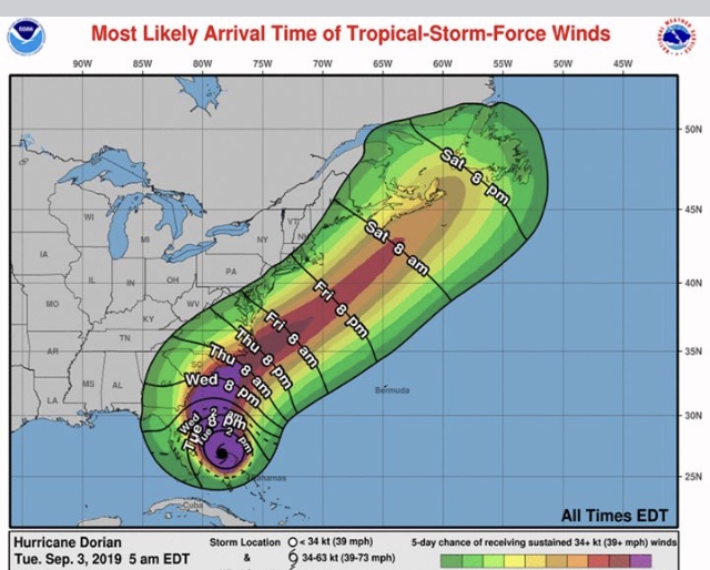
The southern eyewall may be “down” to a Cat 3 storm with 120 mph winds, but it still hasn’t moved from the northern edge of Grand Bahama. However, today should be moving day, later this morning. Finally, this monster will go on his way parallel to the Florida Coast, passing Georgia late Wednesday, Charleston early Thursday and now we focus on North Carolina.
The expectations and recommendations have not changed since yesterday. The cone of uncertainty has now cleared some land areas including Georgia. But while there will be no DORIAN landfall there, count of significant DORIAN-effects as the storm passes offshore. And that’s most important to remember: it still is gonna get nasty.
The Bahamian story is not done. Years of recovery (see MICHAEL, IRMA, MARIA, KATRINA). Economy is shot, lives have been lost, almost total destruction from continuous major hurricane winds over two days and 25’ storm surge. You may think the “worst” is over. It’s not for that “family” and for our “family”.
Storm surge warnings have been extended up the Georgia Coast for 4-7 feet of water above already high tides. That sounds too “high” to me depending on the track of DORIAN. If you flooded for MATTHEW, you are likely to flood again, perhaps not as bad. Take action now to protect your home and family from water.
Tropical storm warnings are now posted for the South Georgia Coast and I would expect those warnings to be extended up to Charleston. Note that the risk of damaging winds diminishes as you get inland. Officials are particularly concerned about the water though.
Rainfall amounts are less this morning, 3-6” along coastal areas, much less inland, and expanding rainfall totals toward the Carolinas. Tropical-storm-force winds will take down tree limbs, even a few trees, and a moderate loss of power is expected from the wind damage. The certainly verifies the evacuation orders and today may be your last chance to move out of harm’s way.
DORIAN FACTS: 120 mph winds, movement noted to the WNW at one mile per hour, pressure up to 952 mb, still 110 miles ENE of West Palm Beach. Tropical storm warnings now extended northward to Altamaha Sound, Georgia. No other changes.
BTW, we have TD#7 in the Western Gulf now formed, could be named later today. Tropical storm warnings posted for NE Mexico.
Stay safe everyone
John Wetherbee, CBM
Meteorologist
The opinions expressed are by the writer using data from the National Weather Service and does not represent any government agency, company, business or syndication, charity organization or media/digital outlet. Any copy or reproduction of this article without expressed written consent is strictly prohibited. Do not make decisions based on these opinions but consult the NWS directly through www.weather.gov.

Be the first to comment