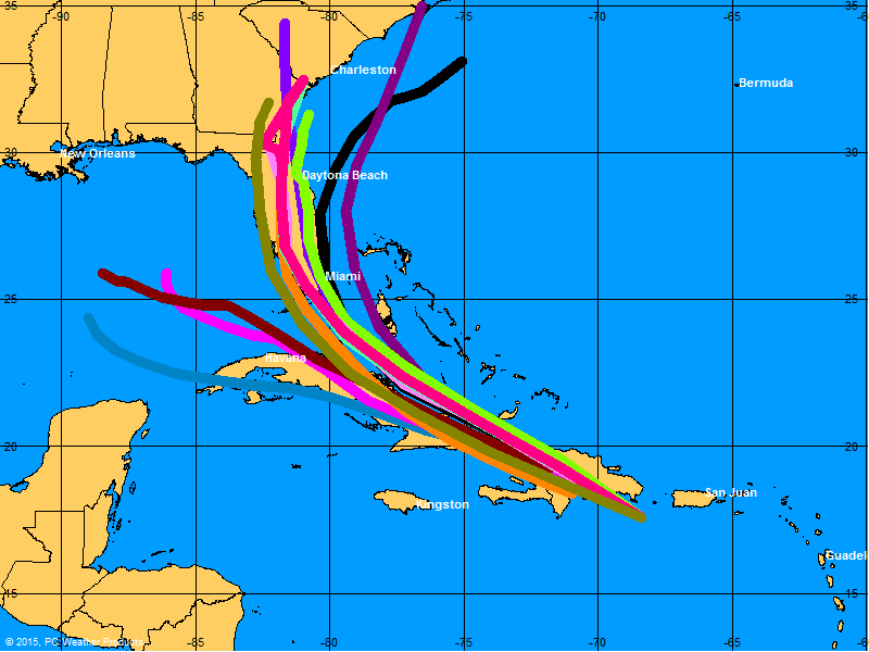
…ERIKA SPREADING HEAVY RAINS AND GUSTY WINDS INTO THE DOMINICAN
REPUBLIC…
SUMMARY OF 200 PM AST…1800 UTC…INFORMATION
———————————————-
LOCATION…17.7N 70.2W
ABOUT 60 MI…95 KM SW OF SANTO DOMINGO DOMINICAN REPUBLIC
ABOUT 305 MI…490 KM SE OF GREAT INAGUA ISLAND
MAXIMUM SUSTAINED WINDS…50 MPH…85 KM/H
PRESENT MOVEMENT…W OR 280 DEGREES AT 18 MPH…30 KM/H
MINIMUM CENTRAL PRESSURE…1009 MB…29.80 INCHES

WATCHES AND WARNINGS
——————–
CHANGES WITH THIS ADVISORY:
The Tropical Storm Warning has been discontinued for Puerto Rico,
Vieques, and Culebra.
SUMMARY OF WATCHES AND WARNINGS IN EFFECT:
A Tropical Storm Warning is in effect for…
* Dominican Republic
* Haiti
* Southeastern Bahamas
* Turks and Caicos Islands
* Central Bahamas
A Tropical Storm Watch is in effect for…
* Northwestern Bahamas
* The Cuban Provinces of Ciego de Avila, Camaguey, Las Tunas,
Holguin, and Guantanamo
A Tropical Storm Warning means that tropical storm conditions are
expected somewhere within the warning area.
A Tropical Storm Watch means that tropical storm conditions are
possible within the watch area, generally within 48 hours.
Interests elsewhere in eastern and central Cuba, as well as the
southern Florida Peninsula and Florida Keys, should monitor the
progress of Erika.
DISCUSSION AND 48-HOUR OUTLOOK
——————————
At 200 PM AST (1800 UTC), the center of Tropical Storm Erika was
located near latitude 17.7 North, longitude 70.2 West. Erika has
been moving westward near 18 mph (30 km/h) for the past several
hours. A motion toward the west-northwest is expected to being
later this afternoon or tonight and continue through Sunday. On
the forecast track, the center of Erika will move over the Dominican
Republic and Haiti during the next few hours, move near the Turks
and Caicos Islands tonight, and move near the central and
northwestern Bahamas Saturday and Saturday night.
Maximum sustained winds are near 50 mph (85 km/h) with higher
gusts. Some weakening is forecast this afternoon and tonight as
Erika moves over land, followed by little change in strength through
Saturday night.
Tropical storm force winds extend outward up to 150 miles (240 km)
to the east of the center. Punta Cana at the eastern end of the
Dominican Republic has been reporting wind gusts of 40 mph (64 km/h)
for the past few hours.
The minimum central pressure based on Hurricane Hunter aircraft data
and surface observations is 1009 mb (29.80 inches).
HAZARDS AFFECTING LAND
———————-
WIND: Tropical storm conditions are currently spreading across
portions of the Dominican Republic. Tropical storm conditions are
expected to spread across Haiti this afternoon, the Turks and Caicos
Islands and the southeastern Bahamas later this afternoon and
tonight, and the central Bahamas on Saturday. Tropical storm
conditions are possible in the northwestern Bahamas by Saturday
night.
RAINFALL: Erika is expected to produce total rainfall accumulations
of 3 to 6 inches with maximum amounts of 10 inches possible across
portions of the Dominican Republic and Haiti, the Turks and Caicos
Islands, and the southeastern and central Bahamas through Saturday.
An additional 1 to 2 inches is expected for Puerto Rico. These
rains could cause life-threatening flash floods and mud slides.


Be the first to comment