
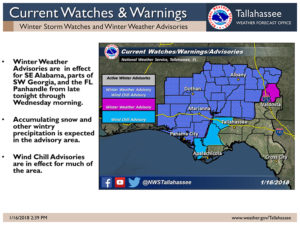
The National Weather Service has issued a 3:00 p.m. update regarding the approaching winter weather for southwest Georgia.
“The combination of sub-freezing temperatures and a strong upper level trough approaching our area will result in a chance of light snow, mainly for SE Alabama, SW Georgia, and the Florida Panhandle. Wind chills below 20 are also possible for these areas.
Timing:Starting late tonight across SE Alabama, and possibly spreading southeastward into FL Panhandle and SW Georgia overnight –Wednesday morning. Peak impacts from 2-10 AM on Wednesday morning and ending by early Wednesday afternoon.
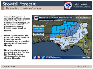
Impacts:Forecast snow accumulations of one-half to 1 inch could lead to slick roads. Wind chills below 20 could also be hazardous to people outdoors for extended periods of time.
Winter Weather Advisories and Wind Chill Advisories are in effect for northern and western parts of our area during Wednesday morning”


Be the first to comment